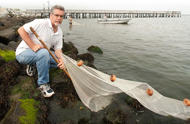


Tim Targett, professor of marine biosciences, is Delaware’s lead investigator on a regional project to evaluate how altered shorelines affect life in the coastal bays of Delaware, Maryland and Virginia.

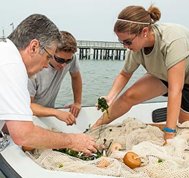
From left, Tim Targett, Mike Torre and Rachel Dixon examine the catch, which includes Atlantic silversides, blue crabs, a puffer and mummichogs.
As sea level rises, why can’t we just build sea walls and armor the coast with riprap? A regional scientific reconnaissance mission is revealing what some of the ecological costs of such choices could mean.
Waves splash around Tim Targett’s knees, as he anchors his end of the seine along a section of shoreline covered in piles of rocks—riprap—near Lewes, Del. Graduate student Rachel Dixon wades toward him holding taut her end of the 6-foot-high, 50-foot-long net. They then carefully move the ends of the net together, forming a fish corral.
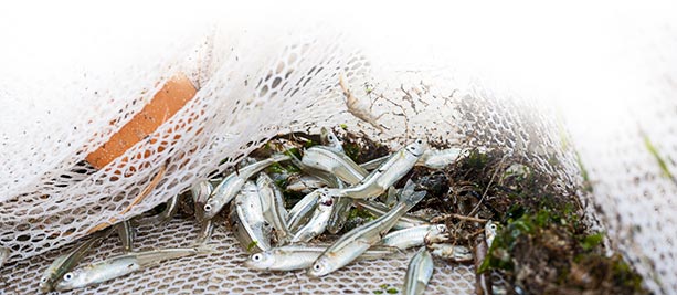
When they haul in and open the net, handfuls of fish flip about, some with sides glinting in the sun like a metallic racing stripe. They are Atlantic silversides—small fish that typically swim in schools as a survival strategy because, to larger fish, they represent supper.
“The Atlantic silverside is one of our most important forage fish, providing food for striped bass, Atlantic mackerel, bluefish and other species,” notes Targett, a professor of marine biosciences in UD’s College of Earth, Ocean, and Environment.
Targett is examining the abundance and diversity of fish using different shoreline types, including shores “hardened” with bulkheads and riprap, whether installed to help morph farmland into a bayside development or to fend off a rising sea. Scientists estimate that up to 80 percent of the shoreline in some Chesapeake Bay tributaries have been altered with such structures.
Targett leads the Delaware portion of a scientific reconnaissance mission launched by the National Oceanic and Atmospheric Administration (NOAA) three years ago to evaluate how altered shorelines affect life in the coastal bays of Delaware, Maryland and Virginia. Finfish, shellfish and sea birds, marsh grasses and submerged aquatic vegetation are all a focus of the study, which encompasses estuaries large and small, from the Chesapeake and Delaware bays to Delaware’s Indian River Bay.
The $4-million, five-year project, supported by NOAA’s Center for Sponsored Coastal Ocean Research and headquartered at the Smithsonian Environmental Research Center near Edgewater, Md., involves more than 15 collaborating scientists from universities and institutes across the region, as well as state resource managers.
Working together, they want to determine the amount of natural shoreline needed to sustain living resources and develop models that can predict the cumulative impacts of multiple stressors on habitat quality, including shoreline hardening, land use changes and the expansion of Phragmites, an invasive reed.
According to NOAA, such a predictive capability would help transform resource management from the current “parcel by parcel” approach to one in which regional ecosystem impacts factor significantly into the decision-making process.
As sea level rises, so does increased pressure to protect the coast with bulkheads, which are retaining walls typically made of wood, metal or concrete; or with riprap. “Riprap-sills”—stone banks with marsh grasses planted immediately behind them—also act as shoreline stabilizers.
Although older bulkheads exist in Delaware, it’s important to note that no new bulkheads are being permitted in the state, and state agencies are recommending that landowners install riprap-sills.
In Delaware’s coastal bays, Targett and his graduate students are assessing the ecological impact of such altered shorelines by evaluating where fish prefer to live, as measured by their abundance and diversity at six shoreline types: bulkhead, riprap, riprap-sill, sandy beach, invasive Phragmites (common reed) and native Spartina (smooth cordgrass).
“We’ve approached this question of preferred fish habitat in a very spatially and temporally replicated way,” Targett says. “We were able to sample very intensively at these six shoreline types and catch thousands of fish. All were kept alive, counted, measured and released.”
During sampling operations from early June through late September 2010 at 20 sites in the shore zone along Indian River Bay and two of its tributaries—Indian River and Pepper Creek—Targett and his team caught and identified 102,343 fish.
Although 28 species of fish were recorded, five species accounted for about 95 percent of the total catch: the mummichog, Atlantic silverside, Atlantic menhaden, striped mullet and striped killifish.
The Spartina shoreline had the greatest density of fish, followed by the beach shoreline. Riprap and bulkhead areas had the least fish density, and no species preferred Phragmites over the other shorelines.
Additionally, the team examined dissolved oxygen (DO) fluctuations among the shoreline types, recording data over 24-hour cycles during a two-month period. They found that DO levels commonly went below the 4.8 mg/l threshold established by the Environmental Protection Agency as necessary for growth and the 2.3 mg/l threshold for survival — not good for fish. They also found differences among the shoreline types, with Spartina shorelines having the greatest DO levels, and bulkhead shorelines the lowest.
Another facet of the study, focusing on the preferred spawning habitat of Atlantic silversides, was reported by Richard Balouskus and Targett in Estuaries and Coasts in March 2012. Balouskus, one of Targett’s advisees, received his master’s degree in May 2012 and is now a biologist at ASA, a global science and technology solutions company.
During 50 sampling days in spring 2010, the scientists collected over 3 million Atlantic silverside eggs. Although the fish’s whitish-yellow eggs were deposited at all six shoreline types, more than 93 percent were found on Spartina shorelines, and most of the eggs (91 percent) were collected from the filaments of Enteromorpha, a species of green algae.
“The Mid-Atlantic region has seen a decrease in Spartina in estuaries during the past few decades, while invasive Phragmites and several types of shoreline hardening have become more common, and that’s of concern,” Targett notes. “Our research shows that ‘living shorelines,’ especially those containing Spartina, are very important to fish.”
Targett says the next phase of the study, which will continue in spring and summer 2013, focuses on Delaware Bay and the ecological impacts of riprap, the primary hard structure used along the bay to stabilize the shoreline. He and graduate student Michael Torre are comparing abundances of predatory species such as weakfish, striped bass and bluefish along riprap and beach areas near the Lewes-Cape May Ferry Terminal, Mispillion Inlet and Port Mahon on the bay’s southwest shore.
“Our research shows that ‘living shorelines,’ especially those containing Spartina, are very important to fish.”
— Tim Targett


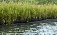
More than 93 percent of the Atlantic silverside eggs collected by the UD team were deposited along shorelines bordered by the marsh grass Spartina.