
Page 50 - UD Research Magazine Vol5-No1
P. 50
Full circle
For Moline, the work in Palau that started—and con- tinues—with a scientific focus, also has become personal. His grandfather’s scrapbook in- cludes notes about an airman who went missing from the ship. BentProp is aware of the serviceman, and collectively they have been trying to find him over the last 20 years.
While the “Hollywood ending” to the story would be to aid in the recovery of the airman mentioned in his grandfather’s journal, Moline is firm that this is not the mission.
“BentProp believes there are about 70 MIAs that are recov- erable from nearly two dozen aircraft downed in Palau. We look forward to continuing the work to bring these servicemen home,” he said.
Abou
ROV
The Outland 1000 is a remote operated vehicle (ROV) that is controlled by an operator over a tether cable. Equipped with many add-ons, this ROV is versatile for many types of research, including low-visibility sonar mapping, real-time video surveying and data collection. A manipulator component enables grab sampling and vehicle retrieval, among other things.
This type of unmanned underwater vehicle (UUV) provides real-time video and real-time scanning sonar to investigate subsur- face environments. The sonar works by looking forward and using sound, or acoustics, to sweep from left to right to create a picture. In murky water, imaging sonar helps researchers acquire a visual representation of what they would see if the water were clear.
DIMENSIONS: Length: 66 cm; Width: 38 cm; Height: 26.67 cm MISSION DURATION: Indefinite
TRAVEL DISTANCE: 300 m
MAXIMUM DEPTH: 300 m
RECENT MISSION: Assess- ing artificial reefs and associ- ated biological communities off the Delaware coast and rescuing an AUV in the Cayman Islands.
Mark Moline
leafs through his grandfather’s scrapbook.
LISA TOSSEY
48 | UD RESEARCH
HHH
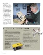
Aerial Vehicles
The DJI Phantom and Phantom 2 Quadcopter un- manned aerial vehicles (UAVs) are the latest addition to the Robotic Discovery Laboratory fleet.
Equipped with sensors, a high-
definition camera and GPS technology,
the UAVs provide a unique perspective for
data collection. They are transported and
deployed by a single operator, and can soar above and capture high-resolution imagery and video.
The UAVs will be used for coastal and marsh research on the Delmarva Peninsula. The top-down view of coastal areas will
provide new insights into habitat growth and decay as well as offer new territory for image analysis research.
DIMENSIONS: Diagonal length: 35 cm MISSION DURATION: 20 minutes TRAVEL DISTANCE: 300 m MAXIMUM DEPTH: 300 m
FUTURE MISSIONS: Studying the effects of
sea level rise and severe storms in the mid-Atlantic.
