


Javascript is required to view this video
Superstorm animation
UD researchers show Sandy's explosive development


6:23 p.m., Nov. 2, 2012--A computer animation produced by University of Delaware researchers shows the explosive development of Hurricane Sandy, the superstorm and its unusual track.
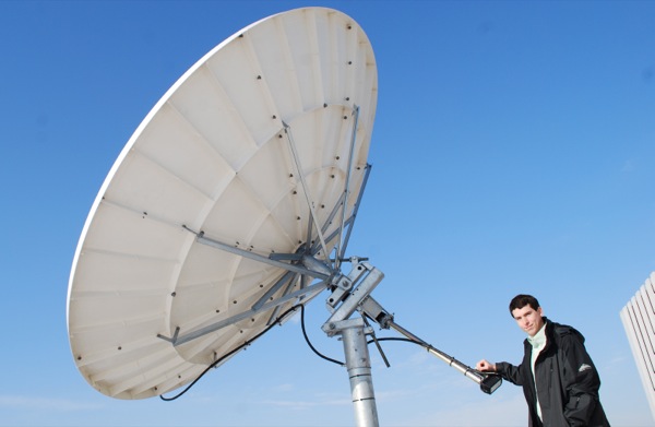
Matt Shatley, computer research specialist in UD’s College of Earth, Ocean, and Environment (CEOE), assembled the animation by digitally stitching together about 800 infrared images taken by GOES, the Geostationary Operational Environmental Satellite, which keeps a continuous eye on the continental United States and the rest of the Western Hemisphere. The animation represents the period from Oct. 22 to Oct. 31.
Research Stories

Chronic wounds
Prof. Heck's legacy
“Because the satellite is stationary, it’s allows us to receive a constant stream of data and observe changes over the same geographic area,” Shatley says, crediting UD geography professor and Delaware State Climatologist Daniel Leathers with the idea to create the animation. It took Shatley about a day to put the animation together.
“Once Sandy moved along the coast of the United States, it began to interact with a strong upper-level jet stream causing it to become a hybrid tropical/extratropical storm,” Leathers notes. “As it moved over the waters of the Gulf Stream, Sandy continued to have tropical characteristics, as thunderstorms once again began to grow around the eye. In the end, this hybrid nature is what caused the storm to be so strong and so large!”
The superstorm’s impacts on Delaware included record flooding along the Atlantic and Delaware Bay coasts. The lower wind speeds across Delaware helped to lessen the number of downed trees and power lines compared to the state’s northern neighbors, according to Leathers.
Shatley serves as CEO’s satellite receiving station specialist. Satellite receiving stations installed on the roof of Willard Hall Education Building two years ago enable UD researchers to access data as it streams from space.
Shatley notes that CEOE researchers both at the Newark campus and at the Smith Global Visualization Room at the Hugh R. Sharp Campus in Lewes work closely with Rutgers ocean scientists on data visualization projects. With New Jersey and New York bearing the brunt of Sandy’s wrath, the UD team is now giving their colleagues a helping hand.
“We’re helping to supply their data needs,” Shatley says. “We’re backing them up.”
Article by Tracey Bryant
Photo by Lisa Tossey