


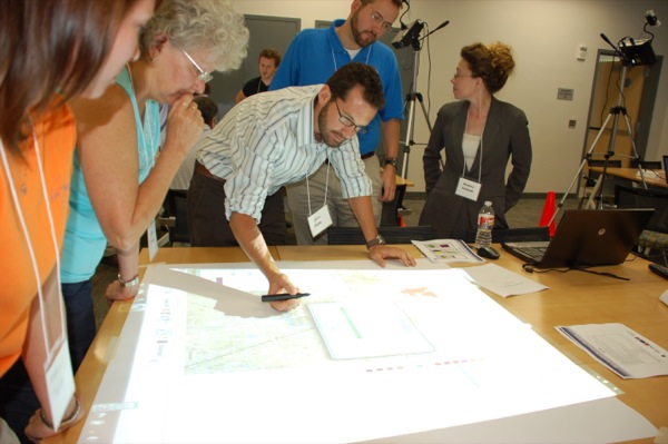
Gathering around the weTable
Upcoming conference to show how Nintendo Wii can aid regional planning


11:21 a.m., Feb. 21, 2013--The Nintendo Wii has made its way into municipal meetings — and not for attendees to play a game of virtual baseball.
Community planners have transformed the video game console into an interactive tool for mapping out regional development and environmental impacts.
Campus Stories

From graduates, faculty
Doctoral hooding
“This is cost-effective, off-the-shelf technology that facilitates public input and collaboration at a whole new level,” said Ed Lewandowski, coastal communities development specialist with the Delaware Sea Grant College Program.
Lewandowski uses the “weTable” system in conjunction with CommunityViz mapping software to help groups visualize land-use scenarios and make changes as the discussion progresses. He brings along a projector, tripod, laptop computer, light pen and Wii remote to set up on the nearest tabletop.
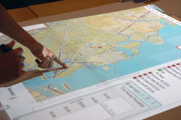
The tripod raises the projector to beam a large image of the laptop’s screen onto the table, which participants gather around. The light pen can manipulate the image, just like a computer mouse.
The Wii remote detects the light pen’s location and transmits a signal to the laptop, which runs software based on white board technology. Participants share control of the projected screen by passing around the pen, marking up images of maps on the table with their suggestions.
Previously, this kind of participatory mapping was cumbersome and inefficient in its preparation and deployment, Lewandowski said. Several maps needed printing, hundreds of cardboard tile cutouts required preparation, participant response was difficult to capture and executing “on-the-fly” analyses was challenging.
Placeways Inc., a company specializing in geographic information systems (GIS) and planning software, developed the weTable, and the Texas Sea Grant College Program at Texas A&M University enhanced the configuration.
Lewandowski, along with Texas Sea Grant’s Steven Mikulencak, are hosting a conference in Houston Feb. 26-27 for hands-on weTable training, supported by NOAA, U.S. EPA and the Ford Foundation. Sea Grant program representatives from Maryland, New York, Florida, Michigan, Minnesota, Pennsylvania, Indiana, Wisconsin, Ohio and Hawaii have already registered for the two-day event. Attendees will include coastal planners, environmental resource managers, educators, public outreach professionals and hazard management agencies from across the country.
The newly trained attendees can put together their own weTable setups for use in their communities back home.
“Land- and resource-use planners have used the weTable with great success to involve the public in crafting plans that provide for sustainable development up to 25 years in the future,” Mikulencak said. “The affordable system is also extremely useful for marine spatial planning, group brainstorming, 2D and 3D visualization and a variety of other public engagement activities.”
Lewandowski spent more than a year using the weTable with organizations throughout Delaware. He helped the Delaware Office of State Planning and Coordination’s Bryan Hall generate master plans for land use in the southern part of the state. Hall finds the setup to be a good icebreaker that is fun to use and can create instant feedback on new ideas.
“We’re able to actively capture it and continue on with the planning process,” Hall said.
Working with the Cape Henlopen Regional Plan, Lewandowski incorporated the weTable into public forums on growth planning along the coast. Community members gather to weigh in on which areas they think are important to address, such as transportation, housing, agriculture, open space and recreation.
Even baseball fields.
Article by Teresa Messmore
Photos courtesy of Texas Sea Grant