


Arctic sea ice
UD researchers, students partner with Naval Academy in Arctic training exercises


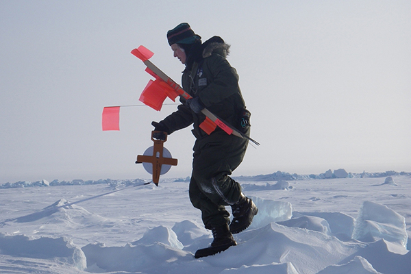
2:57 p.m., Feb. 28, 2013--University of Delaware scientists are embarking to a remote research destination, braving freezing temperatures and high winds to study changes in Arctic sea ice. Their field site is a frozen expanse of the Arctic Ocean along the northernmost shoreline of Alaska.
“We will walk out onto the water,” explained Cathleen Geiger, research associate professor of geography in the College of Earth, Ocean, and Environment. “It’s not often you get to stand on the ocean.”
Research Stories

Chronic wounds
Prof. Heck's legacy
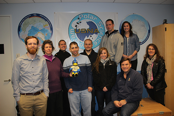
Geiger and her research team will be measuring sea ice using cutting-edge technology to quantify shifts in this dynamic environment, where seawater freezes in the winter and melts in warmer months. At the same time, they will be training undergraduates from the U.S. Naval Academy in techniques that include 3-D mapping of ice contours and cross-referencing locations into geographic information systems (GIS).
The 15-day program is led by the Naval Academy’s Oceanography Department to expand its curriculum on polar regions, with the UD portion sponsored by the National Science Foundation under a grant led by Geiger.
Warmer annual temperatures are increasing the amount of sea ice melt each year, opening previously ice-blocked areas to travel through the Arctic Circle — which government officials have raised as a national security concern.
Geiger has been studying sea ice since the 1980s, when the tail end of the Cold War fueled funding for scientists to examine this natural barrier with Russia. Today the subject has relevance in the context of global warming, with long-term satellite records showing sea ice shrinking over the past 35 years. The amount of sea ice that forms annually is effective for monitoring climate change.
“Sea ice works like a genuine bellwether,” Geiger said. “It will recover very quickly if the planet starts to cool down again.”
While scientists have good data on the two-dimensional footprint of sea ice, calculating the thickness and total volume is more difficult. The ice is floating, for one, and constantly moving and being reshaped by wind and ocean currents.
UD researchers are combining measurements taken underwater, in the air and from space to monitor sea ice changes. In their field experiment March 4-16, one approach will be to simply drill holes in the ice and measure the depth in select locations.
They can’t drill too many holes, or they will destroy the very thing they seek to measure. So they use the drill holes to calibrate a new 3-D ground method and measure ice thickness with electromagnetic induction (EM). This tool involves a transmitter, similar to conventional radar, and a receiver that is sensitive to electrical currents that the transmitter induces in ice and seawater. Traditionally, such devices measure points and profile lines; this work seeks to expand mapping abilities into 3-D.
From the relative strength of the induced currents compared to the transmitter output, the system can determine the distance to the underlying seawater — and hence the ice thickness.
College of Engineering doctoral student Jesse Samluk will assess the usefulness of the 3-D electromagnetic model, enhance its capabilities and validate the results with direct measurements in the field. In particular, he is exploring methods to improve the accuracy of ice thickness measurements near deformed ice features, where measurement errors are highest.
“This project is expected to increase our fundamental knowledge about how radar signals interact with the environment and to enable more accurate predictions of ice thickness distribution as a global climate variable,” explained James Kolodzey, Charles Black Evans Professor of Electrical Engineering and Samluk’s co-adviser with Geiger.
Computer vision doctoral student Scott Sorensen is also participating in the project. No stranger to the Arctic, last summer he participated in a 2012 Arctic expedition aboard the research vessel Polarstern to continuously capture images of the sea ice using a camera system he and fellow doctoral student Rohith Kumar designed in UD’s Video/Imaging Modeling and Synthesis Laboratory (VIMS). He is advised at UD by Chandra Kambhamettu, professor of computer and information sciences and director of VIMS.
For this project, Sorensen will continue working with 3-D imaging of sea ice, specifically comparing various imaging techniques with the georeferencing techniques used in geography.
Geography graduate student Renato Kane and Department of Geography Chair Tracy DeLiberty will round out the UD team, using imagery collected by satellites that are downlinked directly to the National Ice Center. Through this collaboration, they will create multi-scale maps to evaluate changes in the ice.
These mapping methods will be integrated with results from Naval Research Lab (NRL) aircraft flights to map the top half of the ice. The field measurements serve to experimentally verify new algorithms between ice above the water and ice below the water.
The total picture compiled has various practical applications, from mapping walrus habitat to improving ship navigation and aiding in search-and-rescue operations.
As an educational experience for the Naval Academy students, Geiger hopes the field project prepares the next generation of leaders to understand future changes in the environment.
“Students will stand on a world of ice that is changing directly beneath their feet,” Geiger said. “Together with views of the Aurora Borealis, such an experience completely solidifies a person’s understanding of Earth as a moving, changing planet.”
About UD’s College of Earth, Ocean, and Environment
Founded in 1970, the UD College of Earth, Ocean, and Environment brings the latest advances in technology to bear on both teaching and conducting ocean, earth and atmospheric research. The college comprises the School of Marine Science and Policy, the Department of Geological Sciences and the Department of Geography, offering both undergraduate and graduate degrees using an interdisciplinary approach to environmental science.
About UD’s College of Engineering
The UD College of Engineering is home to six academic departments and three degree programs devoted to building a community of problem-solvers focused on challenges associated with sustainability, energy, health care and the environment. World-renowned initiatives led by faculty include 14 college-based research centers and six university-based research centers, all of which provide a fertile training ground for future engineers.
Article by Teresa Messmore and Karen Roberts
Photos courtesy of Cathleen Geiger