|
|
|
|
El Niño is coming. What does it mean for Delaware?
Ranking right up there in popularity with the Big, Bad Wolf, the notorious weather maker El Niño is expected to show up on our doorsteps in the coming months, according to the latest data from the National Oceanic and Atmospheric Administration (NOAA). What causes El Niño, and what will its likely impact be on Delawares weather in the weeks ahead? Two University of Delaware experts share their insights. Xiao-Hai Yan is the Mary A. S. Lighthipe Professor of Marine Studies and co-director of UDs Center for Remote Sensing in the College of Marine and Earth Studies. He made international headlines in 1992 when he showed that satellite images could be used to precisely determine the size and location of the Western Pacific Warm Pool, the spawning ground of El Niño. This vast pool of water, the size of Africa, spans the equator from the Indian Ocean to the western Pacific Ocean and holds the warmest seawater in the worldover 82°F (28°C).
David R. Legates, an associate professor in the geography department in the College of Arts and Sciences, was appointed Delawares state climatologist last year. As such, he maintains an archive of meteorological information that is used to make long-term assessments about changes in the states climate. He relies on data from a variety of sources, including the Delaware Environmental Observing System [www.deos.udel.edu/], which continuously records temperature, wind speed and direction, rainfall, and other information from sensors mounted at 30 meteorological observation sites in and around Delaware. A network of volunteer weather watchers across the state also contributes important data to the system.
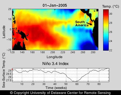
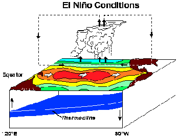
What is El Niño, and how does it form? Yan: El Niño is a warming up of the surface waters of the Pacific Ocean near the equator, which contributes to significant changes in weather patterns around the world. An El Niño typically occurs when the Western Pacific Warm Pool, a huge pool of warm water, moves toward the central equator due to weak trade winds. At the same time, there is no upwelling--in which cold, deep ocean waters rise to the surface--near Peru. As a result, warm water occupies the surface layer of the ocean near South America. Since it usually reaches its fullest extent around Christmas, people called it El Niño, which means the little boy in Spanish, a reference to the Christ child. Contrary to El Niño is La Niña, which is the cooling down of the Pacific Ocean along the equator.
How do you know when an El Niño is being spawned? Yan: A traditionally used indicator is the Southern Oscillation Index (SOI), which is calculated by taking the difference in air pressure between the island of Tahiti in the southern Pacific Ocean, and Darwin, Australia. Generally, a sustained negative value (SOI less than -1) will indicate an El Niño event, while a sustained positive value (SOI greater than 1) will point to a La Niña. Another index that is used, called Niño 3.4, shows deviations in sea-surface temperature in the tropical Pacific. When this index is very positive, it signals an El Niño. In the 1990s, here at UD, we developed a new index based on the direction of rotation of the center of the Western Pacific Warm Pool. If it changes from counter-clockwise to clockwise in rotation, then El Niño is coming.
In 2002, Dr. Yan, you discovered that the warm, choppy waters generated in the Pacific Ocean by El Niño cause a slight imbalance in the Earth's rotation that can extend the length of a day by a few nanoseconds. Have you made any new discoveries about El Niño? Yan: In order to understand the mechanisms driving large-scale circulation in the ocean and the atmosphere, my research team, including research associate scientist Young-Heon Jo and Ph.D. candidates Brian Dzwonkowski and Leon Jiang, has been investigating the role of significant divergent and convergent wind plumes derived from satellite measurements in the Western Pacific Warm Pool zone from 1999 to 2006. Weve found co-existing cell structures of alternating divergent and convergent plumes, which are a mechanism for the convective transport of heat and vapor at the air-sea interface. These wind plumes provide enough energy to drive the atmospheric and ocean circulation that triggers a significant El Niño event. How will the coming El Niño likely affect Delaware's weather in the next few months?
Legates: Generally, El Niño results in wetter and cooler conditions across the southeastern United States and milder-than-average conditions in New England. Since Delaware falls in the middle of the zone between north and south, we usually have a 50-50 chance of our weather going either way. If we have more precipitation, at this point, its more likely that it would fall as rain instead of snow. But its still early on, and things could change as this El Niño is still rather weak. Yan: During strong El Niño episodes, such as in 19971998, Delaware averaged three inches below normal precipitation in the fall, while in November and December, the state tended to be warmer than normal. So far, however, this El Niño looks to be much weaker than the big weathermakers of the past, such as in 199798. Where can people go for more information about El Niño? Yan: The NOAA Climate Prediction Center has information on El Niño at [www.elnino.noaa.gov/]. Legates: If you want to learn more about Delawares weather, one of the best ways is to become a weather watcher for the Delaware Environmental Observing System. Take a look at our web site and then contact my office at (302) 831-4920 if youd like to volunteer with us. Article by Tracey Bryant
|