
Classification
Mapping land cover from multi or hyper spectral imagery can proceed only on the premise that the target cover types are spectrally different from one another. Classification is a process of grouping pixels of similar spectral properties into spectral classes in which each class is assumed to or designed to correspond to a surface cover type. A number of factors can influence the spectral "separability" of target features.
They may be observed to be spectrally different in ground observations and yet not distinguished from one another in the imagery because
The 2 meter ground resolution distance of this data set is sufficiently small in comparison with the size wetland land cover features that the problem of spectral signature mixing should not preclude the identification of most land cover types. Training targets in which ten or more pixels are sufficiently set back from the perimeter of the target to be considered "pure" should not be difficult to obtain in this high spatial resolution data. However, some linear features along ditches, for example, may not be sufficiently wide to be "uncontaminated." There are examples where some pixel spectra of water features can be shown to have been modified by adjacent land pixels in this image (see Appendix II.)
Methods of Classification
The process of classification may be either unsupervised or supervised. Verbyla (1995) provides an excellent elementary presentation. More comprehensive presentations are available in Estes et al . (1983) and in many texts (for example Campbell, 1996, Jensen 1996, Lillesand and Kiefer, 2000, and Richards, 1993.)
Unsupervised Classification Results
In unsupervised classification the spectral variance displayed by the features in the image is partitioned into a specified number of spectral classes without using prior knowledge of the existing cover types or their spectral properties. The partitioned classes must then be identified and labeled by the analyst. In a supervised classification, on the other hand, the analyst previously identifies certain "pure" examples of each target land cover which can be delimited on the ground and identified in the image. The spectral signature of each such target "training site" is determined from the image and used as a starting point for aggregating pixels which have similar spectral characteristics. We applied both approaches to classifying these data in order to compare their effectiveness.
Initial experiments with an unsupervised approach showed that certain spectrally distinct target land cover classes could be identified and segregated. These land surfaces include unconsolidated shore and water and shallow water/tidal flat and land cover which contains vegetation. Salt hay in the wetland was readily identified, although confused with some agricultural areas. Brighter, unshaded forest canopy was readily distinguished, although occasional confusion with high tide bush on the wetlands did occur; however the many pixels of forest shadow in the upland forest were confused with and indistinguishable from wetland vegetation. These experiments demonstrated that it was not possible to perform a satisfactory unsupervised classification of the wetland and upland vegetation at the same time. Nor was spectral separation of forest/upland from the adjacent wetland shrub and/or Phragmites successful.
Additionally, several of the wetland vegetation habitats which we seek to identify display very small spectral differences across the image. Their spectral diversity due to environmental factors appear to introduce greater differences within a given habitat type than exist between these plant species . Particular spectral confusion within wetland areas was experienced between Phragmites and dense canopies of S. alterniflora . Their spectral signatures showed so much diversity and overlapped such that unsupervised classification techniques could not separate the two over significant portions of the image. Each vegetation type showed such spectral variation over the image that no wetland land cover or vegetation type could be represented by a single spectral class. Several different factors appear to have contributed to these variations, some related to conditions on the surface and some related to conditions of the remote imagery. These spectral signatures are strongly affected by the underlying wet mud and water substrate so that canopy density differences result in different mixtures of vegetation spectra with mud/water spectra. Some of the surface conditions are
Extensive information about on-the-ground conditions were required in order to establish "ground truth" targets to associate with their spectral appearance in the image.
Supervised classification:
We next adopted a supervised approach to classifying the wetland vegetation. The image was divided (segmented) into upland and wetland (including water) portions, as noted above, for separate classification. By manual on-screen digitizing a polygon area of interest was defined at very high spatial resolution separating upland forest and agricultural areas from adjacent wetland. The human interpreter was able to distinguish between trees and adjacent wetland shrub and marsh vegetation using spectral cues augmented by spatial cues such as patterns of shadows. The whole study area was segmented into three sections for separate classification: agricultural crop land, forest (including developed/impervious surfaces, and tidal wetland. Tidal wetland was further subdivided into five areas. Signatures of land cover types were separately identified within each area.
Training samples which had been identified in the field were located in the image and their spectral signatures (spectral profiles in the center of the training areas) taken from the image. Training areas were identified using these signatures and visual on-screen interpretation of the hyperspectral image. Identification of maize and soy bean 1999 was aided with the help of a local farmer who identified his 1999 crops in fields totaling some 1200 acres. The identity of land cover in wetland areas was established from on-the ground visitation and from oblique photography from low altitude aircraft. In wetland areas many training sites (5 to 10 per land use category) were required to allow the correct classification of the overall image because the spectral diversity of similar land cover classes across the image. Comparison of spectra from training areas showed good spectral separation among the samples but wide differences are evident in each spectral class presumably because of differences in background water depth, canopy density and necrotic material in the canopy.
Based on these training samples we undertook the supervised classification. In the final classification of agricultural land we have not separated agricultural fields by crop type. The forest section is classified into five classes: forest, shrub, grass, developed land/impervious surfaces, and other. The category "other" contains unidentified surfaces and upland water bodies. The tidal wetland is classified into 13 classes (Table 1). These classes were selected for their potential relevance as wetland habitats and represent the limit of presently possible spectral identification. The 13 wetland classes are
|
Unconsolidated Shore
|
Each class is discussed further below. Aerial and ground views of examples of tidal wetland cases are shown in Appendix III.
The unconsolidated shore has a very bright spectral return. For plant canopy to be visible over the bright sand background, the canopy must be sufficiently heavy to significantly obscure the background.
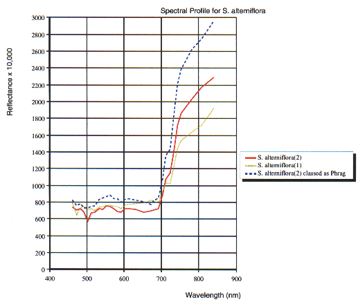
S. alterniflora cover is divided into two classes according to canopy density. Class (1) is lower density, hence its reflectance spectrum shows more influence of the underlying water and marsh surface. Class(2) has a higher density canopy and is usually associated with higher marsh elevations than class (1). We have noted that there are frequent examples of confusion between pixels of the alterniflora class (2) and Phragmites. Three examples of apparent reflectance spectra for S. alterniflora illustrate this confusion.
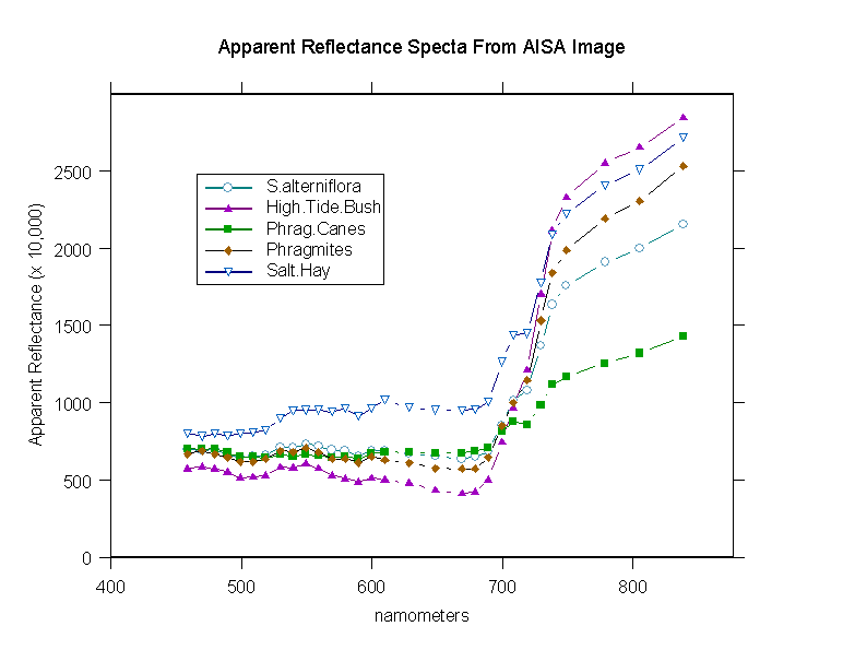
The Salt Hay vegetation shows a very wide spectral range. Lodged patches of salt hay produce highly recognizable bright spectra in the image. This high visible-band reflectance is shown in a comparison of apparent reflectance spectra for 5 vegetation types . However, there are examples of freshwater broad leaf vegetation confused with salt hay. Non-lodged salt hay, which shows a clump (or hummock) habit, may also be recognized in this class spectrally. Such areas can be noted along the northern margin of the lagoon. However, this identification is less secure elsewhere.
Of the two Phragmites classes, dead Phragmites canes standing after herbicidal treatment are distinct spectrally. While the dead canes themselves are not visible in vertical view, the absence of a green vegetation spectral signature against the wet marsh surface background, renders these patches readily identifiable. Regrowing Phragmites within them is also identifiable. Compare the spectra Phragmites and Phragmites canes.
Live Phragmites stands are more difficult to reliably identify spectrally in this image even after extensive ground truthing. At the time of the image Phragmites canopies from place to place showed considerable variety of progression toward senescence. We found frequent confusion with dense canopies of S. alterniflora . Much of our ground truth sampling was directed toward establishing a spectral distinction between these classes. In the end it was necessary to edit the mapping of this class based on observations on the ground and from visual interpretation of the oblique aerial photographs.
The High Tide Bush could be interpreted spectrally in local areas after ground visitation and with the assistance of the oblique photography. The May aerial oblique photographs revealed these shrubs particularly well. Narrow strips along ditches may not be wide enough to fill pixels sufficiently produce spectra distinguishable from the surrounding marsh.
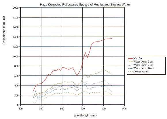
Shallow Water/Tidal Flats are mud flat areas that are inundated more than one half of the time so that S. alterniflora tends not to grow. These flats may have a very sparse canopy of S. alterniflora or be bare of vegetation. They are spectrally identifiable as above water or inundated by only a centimeter or two of water. The spectra of this class show a mixture of the strong influence of wet mud and water with a slight evidence of green vegetation. The green vegetation signal may be due either to algae or vascular vegetation. Water depth of this class in the image is estimated to be less than 2cm. The Figure Mudflat and Water Spectra shows spectra from the haze corrected image for mudflat, and lagoon water 2 to 16 cm deep and deeper.
Open water is sufficiently deep that the spectral signature does not suggest the influence of signal from the bottom. From our observations, water depth in these areas may be as little as 10 cm or even less. Much of the lagoon is, in fact, only 10 to 20 cm deep at low tide.
Developed and Impervious Surfaces within the wetland section are roads and residences. This class in upland portion of the image also includes a number of larger buildings, especially chicken houses.
The areal extent of all features classified in the three sections of the study area is 10,767 ha. A breakdown of area by class is presented in Tables 1 and 2. The 1999 Land Cover Figure shows the classification.
Table 1. Tabulated Area in Agriculture and Forest Images
| Class Name | Area (ha) | % Upland Area |
| Field Crop | 2827 | 45 |
| Forest | 2964 | 47 |
| Shrub | 1 | - |
| Grass | 292 | 5 |
| Developed | 202 | 3 |
| Other | 11 | - |
| Total | 6297 | 100 |
Table 2. Area of Wetland Classes from the image in Hectares
| Class Name | Area (Ha) | % of Wetland Area |
| Unconsolidated Shore | 61 | 1.4 |
|
Vegetated
Unconsolidated. Shore |
15 | 0.3 |
| Developed/Impervious | 25 | 0.6 |
|
Emergent Wetland:
S. alterniflora (1) |
1817 | 40.1 |
|
Emergent Wetland:
S. alterniflora (2 ) |
815 | 18.3 |
|
Emergent Wetland:
Salt Hay |
343 | 7.7 |
|
Emergent Wetland:
Phragmites , live |
212 | 4.7 |
|
Emergent Wetland:
Phragmites , canes |
142 | 3.2 |
|
Emergent Wetland:
High Tide Bush |
170 | 3.8 |
| Forest | 68 | 1.5 |
|
Shallow Water/ Mud Flat
( < ~2 cm deep) |
284 | 6.4 |
|
Open Water
(> ~2 cm deep) |
513 | 11.5 |
| Total Wetland Area | 4463 | 100 |